The theory of plate tectonics is based on a broad synthesis of geologic and geophysical data. It is now almost universally accepted, and its adoption represents a true scientific revolution, analogous in its consequences to quantum mechanics in physics or the discovery of the genetic code in biology. Incorporating the much older idea of continental drift, as well as the concept of seafloor spreading, the theory of plate tectonics has provided an overarching framework in which to describe the past geography of continents and oceans, the processes controlling creation and destruction of landforms, and the evolution of Earth’s crust, atmosphere, biosphere, hydrosphere, and climates. During the late 20th and early 21st centuries, it became apparent that plate-tectonic processes profoundly influence the composition of Earth’s atmosphere and oceans, serve as a prime cause of long-term climate change, and make significant contributions to the chemical and physical environment in which life evolves.
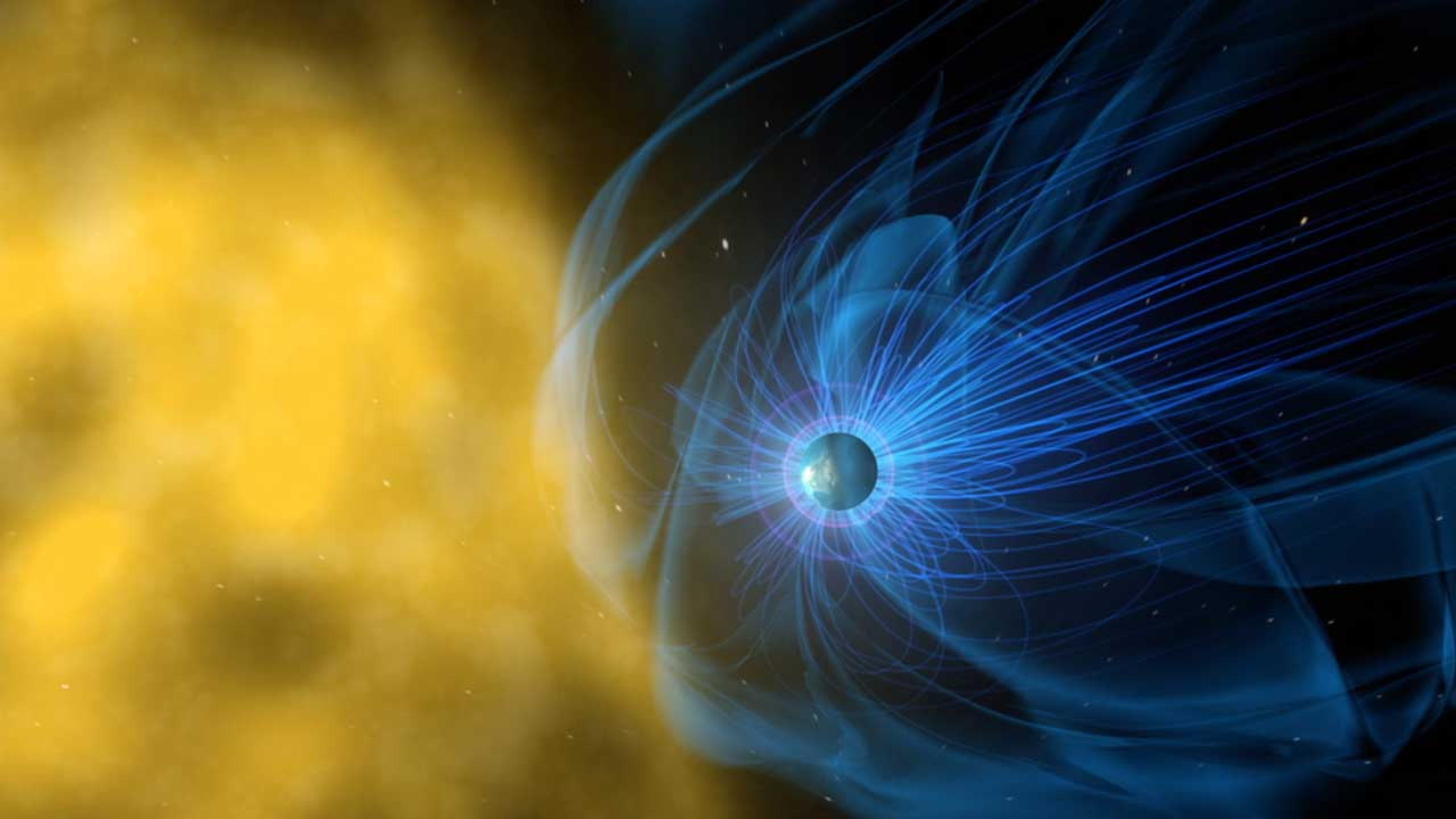
A magnetosphere is the volume of space around an astronomical object that is controlled by that object’s magnetic field. The Earth’s magnetosphere is the cavity formed by the Earth’s magnetic field in the flow of plasma from the Sun known as the solar wind. The interaction with the solar wind deforms the Earth’s basically dipolar magnetic field, compressing the field lines on the day side and stretching them out to form a long comet-like tail on the night side. On the day side, the magnetosphere extends out to a distance of approximately 10 Earth radii, while the magnetotail extends several hundred Earth radii in the antisunward direction. The magnetosphere contains various large-scale regions, which vary in terms of the composition, energies, and densities of the plasmas that occupy them. The sources of the plasmas that populate these regions are the solar wind and the Earth’s ionosphere; the relative contributions of these two sources to the magnetospheric plasma vary according to the level of geomagnetic activity.
Glaciology is an interdisciplinary Earth science that integrates geophysics, geology, physical geography, geomorphology, climatology, meteorology, hydrology, biology, and ecology. The impact of glaciers on people includes the fields of human geography and anthropology. The discoveries of water ice on the Moon, Mars, Europa and Pluto add an extraterrestrial component to the field, which is referred to as astroglaciology. A glacier is an extended mass of ice formed from snow falling and accumulating over a long period of time; glaciers move very slowly, either descending from high mountains, as in valley glaciers, or moving outward from centers of accumulation, as in continental glaciers. Glaciers can be identified by their geometry and the relationship to the surrounding topography. There are two general categories of glaciation which glaciologists distinguish: alpine glaciation, accumulations confined to valleys; and continental glaciation, unrestricted accumulations which once covered much of the northern continents.
Geodesy is the science which deals with the methods of precise measurements of elements of the surface of the earth and their treatment for the determination of geographic positions on the surface of the earth. It also deals with the theory of size and shape of the earth. Geodesy may be broadly divided into two branches, namely: Geometric Geodesy; Physical Geodesy. Also, known as Satellite Geodesy. Dictionary meaning of Geodesy is dividing the earth and measurement of the earth geometry. Thus geometric geodesy appears to be purely geometrical science as it deals with the geometry of the earth. Satellite geodesy comprises the observational and computational techniques which allow the solution of geodetic problems by the use of precise measurements to, from or between artificial, mostly near thhttp://sciaeon.org/geology-and-geoscience/homee earth satellites. To understand how the shape and size of the earth is determined, three surfaces which are of interest to the geodesists have to be understood clearly. These surfaces are: Physical surface of the earth; Geoid; Reference Ellipsoid.
Gravimetry is the measurement of the strength of a gravitational field. Gravimetry may be used when either the magnitude of gravitational field or the properties of matter responsible for its creation are of interest. The term gravimetry or gravimetric is also used in chemistry to define a class of analytical procedures, called gravimetric analysis relying upon weighing a sample of material.
Geomagnetism refers to the Earth’s magnetic field, which extends from the Earth’s interior to where it meets the solar wind. Roughly speaking, it is the field of a gigantic bar magnet currently tilted about 10 degrees off the Earth’s rotational axis. Unlike a bar magnet, however, the Earth’s magnetic field changes over time, because it is generated by a geodynamo. Relatedly, geomagnetic reversals are shifts in Earth’s magnetic field in which the positions of the magnetic north and south are switched. In modern times, a reversal has usually occurred every 50,000 to 800,000 years, with an average of 200,000 years. A plethora of scientific evidence supports the existence of geomagnetic reversals.
Lithogeochemistry, as used in this presentation, is defined as the determination of the chemical composition of bedrock material with the objective of detecting distribution patterns of elements that are spatially related to mineralization. Mineralogical alteration zones in host rocks around mineral deposits have long been recognized and used as indicators of ore. Such alteration zones are the visible manifestations of physical and chemical changes in the host rocks resulting from either primary reactions associated with ore formation or subsequent secondary reactions between the ore and the host rocks. Chemical alteration halos may be more intense, and therefore detectable, over greater distances than mineralogical halos, since the lattice substitution of elements may be detected chemically without having any mineralogical representation. The scale and intensity of changes in the chemistry of the host rock is a function of the genesis of the ore, the chemistry of the host rock, and the nature of the secondary processes. Appreciation of these factors is fundamental to the successful application of lithogeochemistry to mineral exploration. Lithogeochemistry has application at three levels of exploration: identification of geochemical provinces, favourable ore horizons, plutons or volcanic horizons on a regional reconnaissance scale; recognition of local halos related to individual deposits on a local reconnaissance or follow-up scale; and wall-rock anomalies related to particular ore-shoots on a mine scale.
Geochronology, field of scientific investigation concerned with determining the age and history of Earth’s rocks and rock assemblages. Such time determinations are made and the record of past geologic events is deciphered by studying the distribution and succession of rock strata, as well as the character of the fossil organisms preserved within the strata. Earth’s surface is a complex mosaic of exposures of different rock types that are assembled in an astonishing array of geometries and sequences. Individual rocks in the myriad of rock outcroppings contain certain materials or mineralogical information.
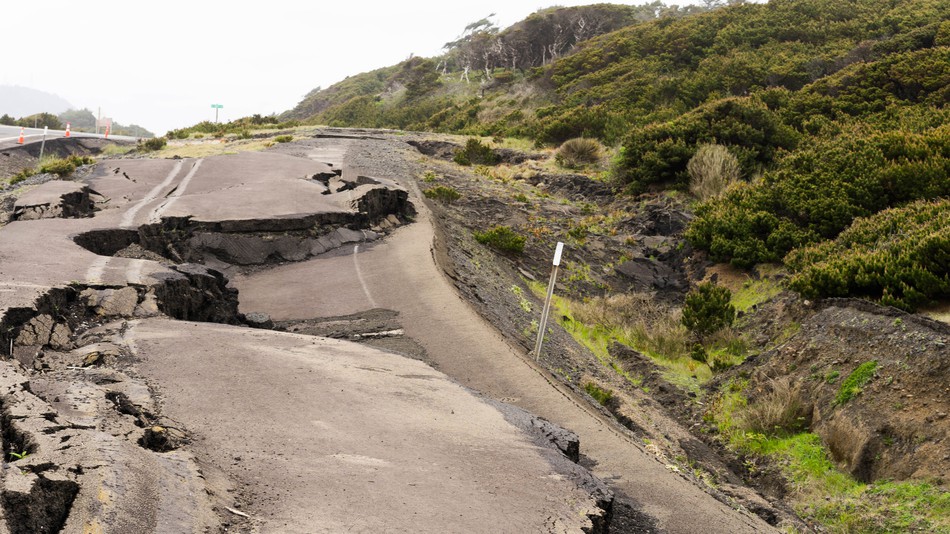
Earthquake, any sudden shaking of the ground caused by the passage of seismic waves through Earth’s rocks. Seismic waves are produced when some form of energy stored in Earth’s crust is suddenly released, usually when masses of rock straining against one another suddenly fracture and slip. Earthquakes occur most often along geologic faults, narrow zones where rock masses move in relation to one another. The major fault lines of the world are located at the fringes of the huge tectonic plates that make up Earth’s crust.